Trail
Rânca – Vârful Parângu Mare
The tour from Rânca to Parângu Mare Peak (2519 m) is a long ridge traverse in the Parâng Mountains, starting from the resort on the Transalpina. It is a hard route, exposed to the wind, running for hours along the main crest past glacial lakes to the massif's highest summit. The reward is a vast panorama over the Parâng ridge — the cost is a full day of walking at altitude.
Figures are indicative: reckon ~5 hours one way and +~900 m of cumulative gain, depending on pace and weather. There are no reliable water sources on the ridge; reliable refilling is usually down in the Rânca area or at the lakes below the crest. Treat the numbers as references.
On the trail
You set off from Rânca on the red stripe heading west, climbing gradually onto the main Parâng ridge. Check the exact marking locally, especially on the long open-alpine sections.
- Start (Rânca). You climb from the resort on a road/path toward the main ridge, soon emerging into gentle alpine terrain.
- On the main ridge. You follow the red stripe over a succession of peaks and saddles (the Cârja, Pâcleșa area), with repeated ups and downs that add up the elevation gain.
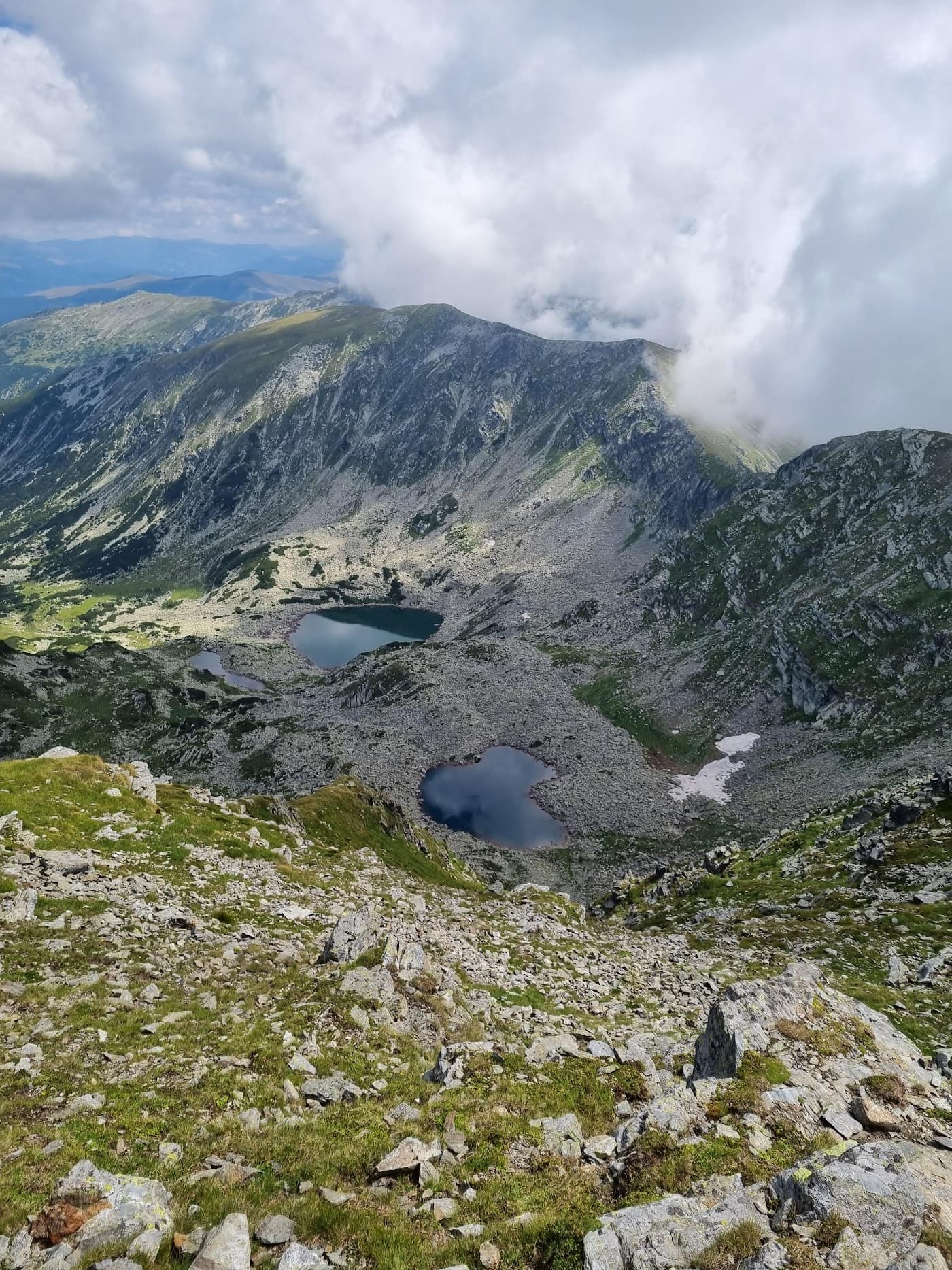
- The glacial lakes. Below the crest you can see lakes (the Câlcescu area and other cirques) — a landmark and a possible water source, off the ridge line.
- Toward Parângu Mare. The last segment climbs rocky ground to the summit, with a few passages that demand sure footing.
- Parângu Mare Peak (2519 m). The highest point of the massif, with a full panorama over the ridge. See Parângu Mare Peak.
The descent usually follows the same route back to Rânca; the tour is long, so budget your time with a buffer.
Equipment and difficulty
Hard difficulty, owing to length, cumulative gain and wind exposure.
- Boots with good grip on grass, rock and scree.
- All your water for the day (2–3 l) — there are no reliable sources on the ridge.
- Wind protection: hardshell, gloves, hat, glasses.
- Insulation, headlamp, map/GPS, compass, first aid.
- Fitness for a long ridge tour.
See info on the Transalpina and access roads to Rânca.
Safety
A long, exposed ridge where wind, weather and fatigue are the main risks.
- Strong wind — the Parâng ridge is wind-beaten; gusts can unbalance you on the crest.
- Weather and lightning — on open alpine terrain you are very exposed to afternoon storms; start early and descend in good time. Check the weather.
- Fog — on the long ridge, poor visibility easily leads to disorientation; follow the marking carefully.
- Distance and fatigue — the return is long; mistakes happen when tired.
- Residual snow — hard snow can linger in saddles and on north slopes early in the season.
When to turn back: if the weather breaks, the wind turns dangerous, or you've fallen behind, retreat toward Rânca while you are still on the gentle part of the ridge. Read the mountain safety and weather guide.
Emergencies: 112 (Salvamont).
⚠ Indicative trail data. Mountain weather changes fast — check the forecast, markings and conditions before you set off. Tell someone your route.
Trail map
Indicative topographic map (OpenTopoMap) — it shows the terrain and the marked paths. Download the route offline and don't rely on signal on the ridge.
Plan your trip
Everything you need for the mountains
Affiliate content: bookings through these offers may earn us a commission, at no extra cost to you.
Stays in the area
Stays nearby
Compare stays available near this place, on the map.
Accommodation map by Stay22 · indicative prices. Bookings through the map may earn a commission, at no extra cost to you.
Frequently asked questions about the Rânca – Vârful Parângu Mare trail
How long does the Rânca – Vârful Parângu Mare trail take?
The stated duration is indicative and depends on your pace, breaks and the weather. Start early and leave enough time to return before dark.
What gear do I need?
Grippy boots, clothing layers, a rain shell, water, food, an offline map/app and a head torch. At altitude, pack a warm layer even in summer.
Is the Rânca – Vârful Parângu Mare trail safe?
With preparation and good weather, yes. Check the forecast, tell someone your route, turn back if the weather worsens and save the emergency number 112 (mountain rescue). Ridge routes require experience.