Trail
Gârda de Sus – Ghețarul Scărișoara
The route from Gârda de Sus to Scărișoara Cave is a short hike to one of the largest underground glaciers in Romania — a block of fossil ice thousands of years old, fitted out for visitors. As a walk it is easy, ideal to combine with other Apuseni sights, but with one important detail: inside the cave it is cold all year round.
Figures are approximate: roughly 1 hour 15 minutes of climbing, +~400 m of gain, waymarked with a blue cross. There is also vehicle access on a forest road close to the cave; on foot it is nicer and safer in bad weather.
On the trail
You start from Gârda de Sus (~800 m), the village in the Arieș valley, following the blue cross uphill towards the plateau.
- Start (Gârda de Sus). Pick up the blue cross in the village. A steady climb on road and path, through scattered homesteads and forest.
- The climb to the plateau. The slope is sustained but with no technical sections. The trail is usually well-trodden and marked; classic Apuseni mountain-village scenery.
- The cave area. You reach the forested plateau above; here are the car park, the cabins and the fitted entrance to the glacier.
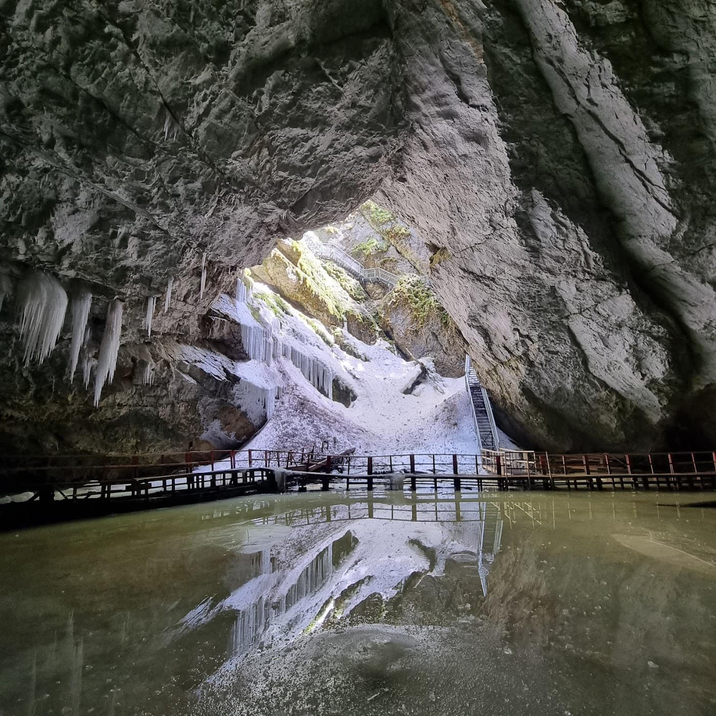
- The chasm and the stairs. The descent into the cave is on metal and wooden stairs, through a wide chasm, down to the ice chamber. The steps can be cold, wet and slippery.
- Scărișoara Cave (the glacier). Below you reach the ice block and the formations of the great chamber. Intense cold even in summer — the temperature stays around 0 °C all year.
After the visit you can combine it with Cetățile Ponorului or other Apuseni sights. See also the Scărișoara Cave page and the Apuseni blog.
Equipment and difficulty
Difficulty is easy to walk, but the cave demands preparation for cold:
- Warm clothes and an extra thermal layer — inside the cave it is cold all year, whatever the weather outside.
- Boots with good grip (the chasm stairs are wet and slippery).
- Water and snacks; do not rely on reliable drinking-water sources along the way.
- A headlamp is handy; check opening hours and the entry fee locally.
See the equipment guide for details. For getting there, see the roads and guesthouses in the area.
Safety
The surface trail is easy; the focus shifts to the cave:
- The cold in the cave — without a thermal layer the visit becomes unpleasant and you can catch a chill; dress up before descending.
- The chasm stairs — cold, wet and slippery; go down carefully and hold the handrail.
- Fog and rain on the plateau — follow the blue cross; on a churned-up forest road, walking is safer.
Retreat option: as the trail is short, you can easily return to Gârda de Sus on the same marking. If the stairs are iced over or the cave is closed, do not force the descent. Check the weather and the safety guide.
Emergencies: 112 (Mountain Rescue / Salvamont).
⚠ Indicative trail data. Mountain weather changes fast — check the forecast, markings and conditions before you set off. Tell someone your route.
Trail map
Indicative topographic map (OpenTopoMap) — it shows the terrain and the marked paths. Download the route offline and don't rely on signal on the ridge.
Plan your trip
Everything you need for the mountains
Affiliate content: bookings through these offers may earn us a commission, at no extra cost to you.
Stays in the area
Stays nearby
Compare stays available near this place, on the map.
Accommodation map by Stay22 · indicative prices. Bookings through the map may earn a commission, at no extra cost to you.
Frequently asked questions about the Gârda de Sus – Ghețarul Scărișoara trail
How long does the Gârda de Sus – Ghețarul Scărișoara trail take?
The stated duration is indicative and depends on your pace, breaks and the weather. Start early and leave enough time to return before dark.
What gear do I need?
Grippy boots, clothing layers, a rain shell, water, food, an offline map/app and a head torch. At altitude, pack a warm layer even in summer.
Is the Gârda de Sus – Ghețarul Scărișoara trail safe?
With preparation and good weather, yes. Check the forecast, tell someone your route, turn back if the weather worsens and save the emergency number 112 (mountain rescue). Ridge routes require experience.